Google Maps Directions API
Our Google Maps Directions API allows you to scrape directions results from Google Maps.
The API endpoint is https://serpapi.com/search?engine=google_maps_directions
Head to the playground for a live and interactive demo.
API Parameters
Search Query
Localization
gl
Optional
Parameter defines the country to use for the Google search. It's a two-letter country code. (e.g., us for the United States, uk for United Kingdom, or fr for France) Head to the Google countries page for a full list of supported Google countries.
hl
Optional
Parameter defines the language to use for the Google Maps Directions search. It's a two-letter language code. (e.g., en for English, es for Spanish, or fr for French). Head to the Google languages page for a full list of supported Google languages.
Advanced Google Maps Directions Parameters
travel_mode
Optional
Parameter defines the travel mode.
Available options:6 - Best (Default)0 - Driving9 - Two-wheeler3 - Transit2 - Walking1 - Cycling4 - Flight
start_data_id
Optional
Parameter defines the data ID of the starting point for the direction you want to search. Find the data ID of a place using our Google Maps API.
Alternatively, you can use start_addr or start_coords.
end_data_id
Optional
Parameter defines the data ID of the ending point for the direction you want to search. Find the data ID of a place using our Google Maps API.
Alternatively, you can use end_addr or end_coords.
Advanced Options
distance_unit
Optional
Parameter defines the displayed distance unit.
Available options:1 - miles0 - km
avoid
Optional
Parameter defines avoid options.
Available options:highways - Highwaystolls - Tollsferries - Ferries
You can also combine multiple options by joining them with a comma (e.g.: highways,tolls).
prefer
Optional
Parameter defines preferred transit options.
Available options:bus - Bussubway - Subwaytrain - Traintram_light_rail - Tram and light rail
You can also combine multiple options by joining them with a comma (e.g.: subway,train).
Parameter works only if travel_mode parameter is set to: 3 (Transit)
route
Optional
Parameter defines route options.
Available options:2 - Fewer transfers3 - Less walking4 - Wheelchair accessible
Parameter works only if travel_mode parameter is set to: 3 (Transit)
time
Optional
Parameter defines the time to travel.
Available options:depart_at:xxxxxx - Specifies the departure time, where xxxxxx is the timestamp. E.g. depart_at:1698229538 specifies the departure time to 2023-10-25 10:25:38 GMT+0000arrive_by:xxxxxx - Specifies the arrival time, where xxxxxx is the timestamp. E.g. arrive_by:1698229538 specifies the arrival time to 2023-10-25 10:25:38 GMT+0000last_available - Takes the last available transit. This option works only if travel_mode parameter is set to: 3 (Transit)
 Serpapi Parameters
engine
Required
Set parameter to google_maps_directions to use the Google Maps Directions API engine.
no_cache
Optional
Parameter will force SerpApi to fetch the Google Maps Directions results even if a cached version is already present. A cache is served only if the query and all parameters are exactly the same. Cache expires after 1h. Cached searches are free, and are not counted towards your searches per month. It can be set to false (default) to allow results from the cache, or true to disallow results from the cache. no_cache and async parameters should not be used together.
async
Optional
Parameter defines the way you want to submit your search to SerpApi. It can be set to false (default) to open an HTTP connection and keep it open until you got your search results, or true to just submit your search to SerpApi and retrieve them later. In this case, you'll need to use our Searches Archive API to retrieve your results. async and no_cache parameters should not be used together. async should not be used on accounts with Ludicrous Speed enabled.
zero_trace
Optional
Enterprise only. Parameter enables ZeroTrace mode. It can be set to false (default) or true. Enable this mode to skip storing search parameters, search files, and search metadata on our servers. This may make debugging more difficult.
API Results
JSON Results
JSON output includes structured data for directions results.
A search status is accessible through search_metadata.status.
It flows this way: Processing -> Success || Error.
If a search has failed, error will contain an error message.
search_metadata.id is the search ID inside SerpApi.
HTML Results
This API does not have a full HTML response, only text.
search_metadata.prettify_html_file contains a link to the prettified version of the result.
It is displayed in the playground.
API Examples
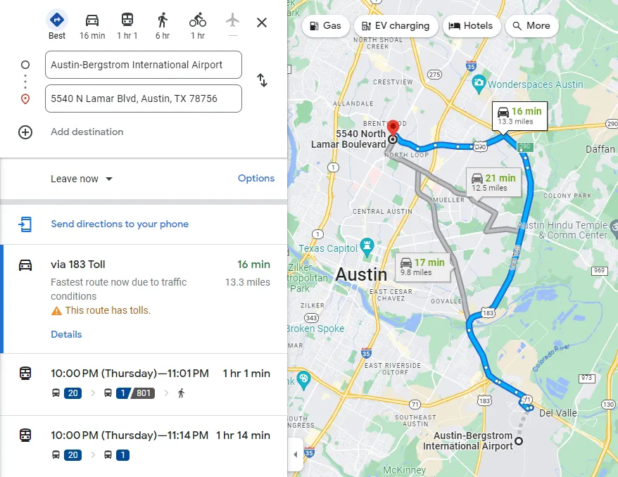
Example with typical directions and transit directions
{
  "search_metadata": {
    "id": "653b24de15afff3a862b65b3",
    "status": "Success",
    "json_endpoint": "https://serpapi.com/searches/6bbeb04e383ea965/653b24de15afff3a862b65b3.json",
    "created_at": "2023-10-27 02:47:58 UTC",
    "processed_at": "2023-10-27 02:47:58 UTC",
    "google_maps_directions_url": "https://www.google.com/maps/dir/Austin-Bergstrom+International+Airport/5540+N+Lamar+Blvd%2C+Austin%2C+TX+78756/data=!3m1!4b1!4m14!4m13!1m5!1m1!1s0x8644b13b8b4aff45:0x1ca7fca8c9dc2768!2m2!1d-97.66635289999999!2d30.197471099999998!1m5!1m1!1s0x8644ca4259a4bacf:0x5782c78a0ae2d9a3!2m2!1d-97.7278869!2d30.3246388!3e6?hl=en",
    "raw_html_file": "https://serpapi.com/searches/6bbeb04e383ea965/653b24de15afff3a862b65b3.html",
    "prettify_html_file": "https://serpapi.com/searches/6bbeb04e383ea965/653b24de15afff3a862b65b3.prettify",
    "total_time_taken": 1.05
  },
  "search_parameters": {
    "engine": "google_maps_directions",
    "hl": "en",
    "start_addr": "Austin-Bergstrom International Airport",
    "end_addr": "5540 N Lamar Blvd, Austin, TX 78756, USA"
  },
  "places_info": [
    {
      "address": "Austin-Bergstrom International Airport",
      "data_id": "0x8644b13b8b4aff45:0x1ca7fca8c9dc2768",
      "gps_coordinates": {
        "latitude": 30.197471099999998,
        "longitude": -97.66635289999999
      }
    },
    {
      "address": "5540 N Lamar Blvd, Austin, TX 78756",
      "data_id": "0x8644ca4259a4bacf:0x5782c78a0ae2d9a3",
      "gps_coordinates": {
        "latitude": 30.3246388,
        "longitude": -97.7278869
      }
    }
  ],
  "directions": [
    {
      "travel_mode": "Driving",
      "via": "183 Toll",
      "distance": 21397,
      "duration": 970,
      "formatted_distance": "13.3 miles",
      "formatted_duration": "16 min",
      "extensions": [
        "Fastest route now due to traffic conditions",
        "This route has tolls."
      ],
      "icon": "https://serpapi.com/assets/google_maps_directions/driving.svg"
      "trips": [
        {
          "travel_mode": "Driving",
          "title": "Get on  State Hwy 71 W  in  Del Valle  from  Hotel Dr  and  Spirit of Texas Dr",
          "distance": 1351,
          "duration": 139,
          "formatted_distance": "0.8 mi",
          "formatted_duration": "2 min",
          "details": [
            {
              "title": "Head  southwest  on  Presidential Blvd  toward  Service Dr",
              "action": "straight",
              "distance": 3,
              "duration": 0,
              "formatted_distance": "10 ft",
              "formatted_duration": "0 sec",
              "icon": "https://maps.gstatic.com/consumer/images/icons/2x/straight_grey800_18dp.png"
            },
            {
              "title": "Slight  right  onto  Service Dr",
              "action": "turn-slight-right",
              "distance": 147,
              "duration": 14,
              "formatted_distance": "482 ft",
              "formatted_duration": "14 sec",
              "icon": "https://maps.gstatic.com/consumer/images/icons/2x/turn_slight_left_grey800_18dp.png"
            },
            ...
            {
              "title": "Turn  left  to merge onto  State Hwy 71 W",
              "action": "merge",
              "distance": 489,
              "duration": 41,
              "formatted_distance": "0.3 mi",
              "formatted_duration": "41 sec",
              "geo_photo": "https://geo0.ggpht.com/cbk?cb_client=unknown_client.gws&output=thumbnail&thumb=2&panoid=5VuJaV4okpHOIlrk6vjVzA&w=203&h=100&yaw=35&pitch=0&thumbfov=114&ll=30.215779,-97.663537",
              "gps_coordinates": {
                "latitude": 30.215778597115996,
                "longitude": -97.66353692926126
              },
              "icon": "https://maps.gstatic.com/consumer/images/icons/2x/merge_grey800_18dp.png"
            }
          ]
        },
        {
          "travel_mode": "Driving",
          "title": "Take  S Hwy 183  and  183 Toll  to  Ed Bluestein Blvd . Take exit  290  from  US-183 Hwy N",
          "distance": 13352,
          "duration": 452,
          "formatted_distance": "8.3 mi",
          "formatted_duration": "8 min",
          "details": [
            {
              "title": "Merge onto  State Hwy 71 W",
              "action": "merge",
              "distance": 883,
              "duration": 33,
              "formatted_distance": "0.5 mi",
              "formatted_duration": "33 sec",
              "geo_photo": "https://geo0.ggpht.com/cbk?cb_client=unknown_client.gws&output=thumbnail&thumb=2&panoid=6W9RImNO1oAtGmrY-BxRyA&w=203&h=100&yaw=271&pitch=0&thumbfov=114&ll=30.218076,-97.667626",
              "gps_coordinates": {
                "latitude": 30.218075561429668,
                "longitude": -97.66762618600264
              },
              "icon": "https://maps.gstatic.com/consumer/images/icons/2x/merge_grey800_18dp.png"
            },
            {
              "title": "Keep  left  to stay on  State Hwy 71 W",
              "action": "turn-left",
              "distance": 155,
              "duration": 6,
              "formatted_distance": "0.1 mi",
              "formatted_duration": "6 sec",
              "geo_photo": "https://geo0.ggpht.com/cbk?cb_client=unknown_client.gws&output=thumbnail&thumb=2&panoid=taShVzROLv_24piCVDKjVw&w=203&h=100&yaw=294&pitch=0&thumbfov=114&ll=30.221939,-97.675603",
              "gps_coordinates": {
                "latitude": 30.22193947835618,
                "longitude": -97.67560270002575
              },
              "icon": "https://maps.gstatic.com/consumer/images/icons/2x/turn_slight_left_grey800_18dp.png"
            },
            ...
            {
              "title": "Take exit  290  to merge onto  Ed Bluestein Blvd",
              "action": "ramp-right",
              "distance": 396,
              "duration": 16,
              "formatted_distance": "0.2 mi",
              "formatted_duration": "16 sec",
              "geo_photo": "https://geo0.ggpht.com/cbk?cb_client=unknown_client.gws&output=thumbnail&thumb=2&panoid=-Kw5hYYw0gH0Ztaz83SYCQ&w=203&h=100&yaw=335&pitch=0&thumbfov=114&ll=30.316653,-97.663226",
              "gps_coordinates": {
                "latitude": 30.316653039874772,
                "longitude": -97.66322628500936
              },
              "icon": "https://maps.gstatic.com/consumer/images/icons/2x/merge_left_grey800_18dp.png"
            }
          ]
        },
        ...
      ]
    },
    {
      "travel_mode": "Transit",
      "via": "every 30 min",
      "start_time": "10:00 PM",
      "end_time": "11:01 PM",
      "distance": 20741,
      "duration": 3696,
      "formatted_distance": "12.9 miles",
      "formatted_duration": "1 hr 1 min",
      "cost": 2.5,
      "currency": "USD",
      "icon": "http://serpapi.com/assets/google_maps_directions/transit.svg",
      "trips": [
        {
          "travel_mode": "Transit",
          "title": "20 Springdale NB",
          "duration": 1519,
          "formatted_duration": "25 min",
          "start_stop": {
            "name": "ABIA Lower Level",
            "stop_id": "4326",
            "time": "10:00 PM",
            "data_id": "0x8644b12fd58ade63:0xe4f74504ec3e0789"
          },
          "end_stop": {
            "name": "Vic Mathias/Auditorium Shores (NB)",
            "stop_id": "2767",
            "time": "10:25 PM",
            "data_id": "0x8644b50468dc089b:0xe538290c1b432609"
          },
          "stops": [
            {
              "name": "New Airport/Employee",
              "stop_id": "5099",
              "time": "10:02 PM",
              "data_id": "0x8644b6d2c44dff0d:0xb675564586691762"
            },
            {
              "name": "1766 71/Thornberry",
              "stop_id": "6241",
              "time": "10:03 PM",
              "data_id": "0x8644b6ceda7d81cd:0x8efd97972d53024d"
            },
            ...
            {
              "name": "150 Riverside/Newning",
              "stop_id": "1249",
              "time": "10:23 PM",
              "data_id": "0x8644b5010bcef057:0x6907542b89870119"
            }
          ],
          "icon": "https://maps.gstatic.com/mapfiles/transit/iw2/svg/bus2.svg",
          "service_run_by": {
            "name": "Capital Metro",
            "link": "http://www.capmetro.org/",
            "route_information": "http://www.capmetro.org/current_schedules/pdf/020.pdf"
          }
        },
        {
          "travel_mode": "Transit",
          "title": "801 Tech Ridge Park & Ride NB",
          "duration": 1440,
          "formatted_duration": "24 min",
          "start_stop": {
            "name": "Vic Mathias/Auditorium Shores (NB)",
            "stop_id": "2767",
            "time": "10:33 PM",
            "data_id": "0x8644b50468dc089b:0xe538290c1b432609"
          },
          "end_stop": {
            "name": "Brentwood Station (NB)",
            "stop_id": "5862",
            "time": "10:57 PM",
            "data_id": "0x8644ca43d075faeb:0x31501d1696f6b5c"
          },
          "stops": [
            {
              "name": "Republic Square Station (NB)",
              "stop_id": "5868",
              "time": "10:35 PM",
              "data_id": "0x8644b508c37bdb85:0xc78e875dbe69f8d8"
            },
            {
              "name": "Austin History Center",
              "stop_id": "2606",
              "time": "10:38 PM",
              "data_id": "0x8644b50bd358ff1d:0x1795bcf1bd51e0ca"
            },
            ...
            {
              "name": "North Loop East Station (NB)",
              "stop_id": "612",
              "time": "10:55 PM",
              "data_id": "0x8644ca68392c5cfd:0x502891f41f80d1cd"
            }
          ],
          "icon": "https://maps.gstatic.com/mapfiles/transit/iw2/svg/bus2.svg",
          "service_run_by": {
            "name": "Capital Metro",
            "link": "http://www.capmetro.org/",
            "route_information": "http://www.capmetro.org/current_schedules/pdf/801.pdf"
          }
        },
        {
          "travel_mode": "Walking",
          "title": "Walk",
          "distance": 307,
          "duration": 276,
          "formatted_distance": "0.2 mi",
          "formatted_duration": "4 min",
          "icon": "https://maps.gstatic.com/mapfiles/transit/iw2/svg/walk.svg",
          "details": [
            {
              "title": "Head  southwest  on  N Lamar Blvd  toward  W Koenig Ln",
              "action": "straight",
              "distance": 244,
              "duration": 220,
              "formatted_distance": "0.2 mi",
              "formatted_duration": "4 min",
              "geo_photo": "https://geo0.ggpht.com/cbk?cb_client=unknown_client.gws&output=thumbnail&thumb=2&panoid=oWMCxXtS-0dz8QtPGrkW6Q&w=203&h=100&yaw=127&pitch=0&thumbfov=114&ll=30.326378,-97.726041",
              "gps_coordinates": {
                "latitude": 30.326378276258698,
                "longitude": -97.72604068429148
              },
              "extensions": [
                "Pass by KFC (on the left in 0.1 mi)"
              ]
            },
            {
              "title": "Turn  right",
              "action": "turn-right",
              "distance": 63,
              "duration": 56,
              "formatted_distance": "207 ft",
              "formatted_duration": "56 sec",
              "geo_photo": "https://geo0.ggpht.com/cbk?cb_client=unknown_client.gws&output=thumbnail&thumb=2&panoid=pww4A9lWzzbMyXgnHRaw_w&w=203&h=100&yaw=223&pitch=0&thumbfov=114&ll=30.324585,-97.727192",
              "gps_coordinates": {
                "latitude": 30.32458534013088,
                "longitude": -97.72719247999947
              },
              "extensions": [
                "Restricted usage road",
                "Destination will be on the left"
              ]
            }
          ]
        }
      ]
    },
    ...
  ],
  "durations": [
    {
      "travel_mode": "Driving",
      "duration": 970,
      "formatted_duration": "16 min"
    },
    {
      "travel_mode": "Transit",
      "duration": 3660,
      "formatted_duration": "1 hr 1"
    },
    {
      "travel_mode": "Walking",
      "duration": 21457,
      "formatted_duration": "6 hr"
    },
    {
      "travel_mode": "Cycling",
      "duration": 3615,
      "formatted_duration": "1 hr"
    }
  ]
}
Example with elevation_profile (Walking)
{
  ...
  "directions": [
    {
      "travel_mode": "Walking",
      "via": "FM 969 E",
      "distance": 25946,
      "duration": 21457,
      "formatted_distance": "16.1 miles",
      "formatted_duration": "5 hr 58 min",
      "icon": "http://serpapi.com/assets/google_maps_directions/walking.svg",
      "elevation_profile": {
        "ascent": 143,
        "descent": 80,
        "max_altitude": 209,
        "min_altitude": 123,
        "formatted_ascent": "469 ft",
        "formatted_descent": "262 ft",
        "formatted_max_altitude": "686 ft",
        "formatted_min_altitude": "404 ft"
      },
      "trips": [
        ...
      ],
    },
    {
      "travel_mode": "Walking",
      "via": "Airport Blvd",
      "distance": 31839,
      "duration": 26275,
      "formatted_distance": "19.8 miles",
      "formatted_duration": "7 hr 18 min",
      "icon": "http://serpapi.com/assets/google_maps_directions/walking.svg",
      "elevation_profile": {
        "ascent": 131,
        "descent": 68,
        "max_altitude": 209,
        "min_altitude": 130,
        "formatted_ascent": "430 ft",
        "formatted_descent": "223 ft",
        "formatted_max_altitude": "686 ft",
        "formatted_min_altitude": "427 ft"
      },
      "trips": [
        ...
      ],
    },
    ...
  ],
  ...
}
Example with flight
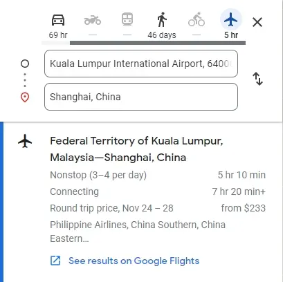
{
  ...
  "directions": [
    {
      "travel_mode": "Flight",
      "icon": "http://serpapi.com/assets/google_maps_directions/flight.svg",
      "flight": {
        "departure": "Federal Territory of Kuala Lumpur, Malaysia",
        "arrival": "Shanghai, China",
        "date": "Nov 24 – 28",
        "round_trip_price": 232.98,
        "currency": "USD",
        "airlines": [
          "Philippine Airlines",
          "China Southern",
          "China Eastern"
        ],
        "nonstop_duration": 18600,
        "formatted_nonstop_duration": "5 hr 10 min",
        "connecting_duration": 26400,
        "formatted_connecting_duration": "7 hr 20 min",
        "google_flights_link": "https://www.google.com/travel/flights?tfs=CAcQAhooEgoyMDIzLTExLTI0agwIAhIIL20vMDQ5ZDFyDAgCEggvbS8wNndqZhooEgoyMDIzLTExLTI4agwIAhIIL20vMDZ3amZyDAgCEggvbS8wNDlkMQ&source=maps&hl=en&authuser=0"
      }
    }
  ],
  ...
}
Example with arrive_around and typical_duration_range
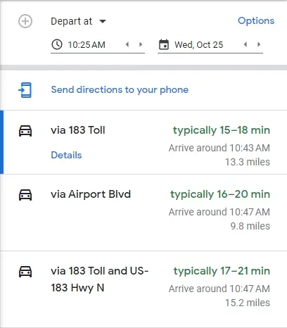
{
  ...
  "directions": [
    {
      "travel_mode": "Driving",
      "via": "183 Toll",
      "distance": 21397,
      "duration": 993,
      "arrive_around": 1698248619,
      "typical_duration_range": "15–18 min",
      "formatted_distance": "13.3 miles",
      "formatted_duration": "17 min",
      "formatted_arrive_around": "10:43 AM",
      "extensions": [
        "Fastest route now due to traffic conditions",
        "This route has tolls."
      ],
      "icon": "https://serpapi.com/assets/google_maps_directions/driving.svg"
      "trips": [
        ...
      ]
    },
    {
      "travel_mode": "Driving",
      "via": "Airport Blvd",
      "distance": 15793,
      "duration": 1077,
      "arrive_around": 1698248851,
      "typical_duration_range": "16–20 min",
      "formatted_distance": "9.8 miles",
      "formatted_duration": "18 min",
      "formatted_arrive_around": "10:47 AM",
      "extensions": [
        "This route has tolls."
      ],
      "icon": "https://serpapi.com/assets/google_maps_directions/driving.svg"
      "trips": [
        ...
      ]
    },
    ...
  ],
  ...
}
JSON structure overview
{
  ...
  "places_info": [
    {
      "address": "String - Address of the place",
      "data_id": "String - The Google Maps data ID of the place, can be used in other SerpApi's Google Maps engines",
      "gps_coordinates": {
        "latitude": "Numeric - Place latitude",
        "longitude": "Numeric - Place longitude"
      },
    }
  ],
  "directions": [
    {
      "travel_mode": "String - Travel mode of the direction",
      "via": "String - Title of the direction",
      "start_time": "String - Start time of the transit",
      "end_time": "String - End time of the transit",
      "distance": "Integer - Distance of the direction, in meters",
      "duration": "Integer - Duration of the direction, in seconds",
      "arrive_around": "Integer - Estimated timestamp of arrival",
      "leave_around": "Integer - Estimated timestamp of leaving",
      "typical_duration_range": "String - Estimated duration range of the direction",
      "formatted_distance": "String - Formatted string of the distance",
      "formatted_duration": "String - Formatted string of the duration",
      "formatted_arrive_around": "String - Formatted string of the estimated arrival time",
      "formatted_leave_around": "String - Formatted string of the estimated leaving time",
      "cost": "Integer - Cost of the transit",
      "currency": "String - Currency of the cost",
      "extensions": "Array - A list of extra information of the direction",
      "icon": "String - URL to the icon of the direction",
      // only available for `Walking` travel mode
      "elevation_profile": {
        "ascent": "Integer - Amount of ascent of the walking in meters",
        "descent": "Integer - Amount of descent of the walking, in meters",
        "max_altitude": "Integer - Maximum altitude of the walking, in meters",
        "min_altitude": "Integer - Minimum altitude of the walking, in meters",
        "formatted_ascent": "String - Formatted string of the ascent",
        "formatted_descent": "String - Formatted string of the descent",
        "formatted_max_altitude": "String - Formatted string of the maximum altitude",
        "formatted_min_altitude": "String - Formatted string of the minimum altitude",
      },
      // only available for `Flight` travel mode
      "flight": {
        "departure": "String - Name of the departing place",
        "arrival": "String - Name of the arriving place",
        "date": "String - Date of the travel",
        "round_trip_price": "Integer - Price of the round trip flight",
        "currency": "String - Currency of the price",
        "airlines": "Array - A list of airline names",
        "nonstop_duration": "String - Duration of the nonstop flight, in seconds",
        "formatted_nonstop_duration": "String - Formatted string of the nonstop duration",
        "connecting_duration": "String - Duration of the connecting flight, in seconds",
        "formatted_connecting_duration": "String - Formatted string of the connecting duration",
        "google_flights_link": "String - URL to Google Flights search",
      },
      "trips": [
        {
          "travel_mode": "String - Travel mode of the trip",
          "title": "String - Title of the trip",
          "distance": "Integer - Distance of the trip, in meters",
          "duration": "Integer - Duration of the trip, in seconds",
          "formatted_distance": "String - Formatted string of the distance",
          "formatted_duration": "String - Formatted string of the duration",
          "start_stop": "Hash - Info about the starting stop",
          "end_stop": "Hash - Info about the ending stop",
          "stops": "Array - Intermediate stops between the starting and ending stops",
          "icon": "String - URL to the icon of the trip",
          "service_run_by": {
            "name": "String - Name of the service runner",
            "link": "String - URL to the service runner",
            "route_information": "String - URL to the route information",
          },
          "details": [
            {
              "title": "String - Title of the detail",
              "action": "String - Action name of the detail",
              "distance": "Integer - Distance of the detail, in meters",
              "duration": "Integer - Duration of the detail, in seconds",
              "formatted_distance": "String - Formatted string of the distance",
              "formatted_duration": "String - Formatted string of the duration",
              "geo_photo": "String - URL to the GEO photo of the detail",
              "gps_coordinates": {
                "latitude": "Numeric - Latitude of the detail",
                "longitude": "Numeric - Longitude of the detail"
              },
              "icon": "String - URL to the icon of the detail",
              "extensions": "Array - A list of extra information of the detail"
            }
          ],
        }
      ]
    }
  ],
  "durations": [
    {
      "travel_mode": "String - Name of the travel mode",
      "duration": "Integer - Duration of the travel mode, in seconds",
      "formatted_duration": "String - Formatted string of the duration",
    }
  ],
  ...
}